


On a country road just northwest of the Arcata Marsh, two drones sit on the tailgate of a pickup truck while a couple of scientists are prepping for flight. For years, they’ve been taking aerial pictures of a former cow pasture.
• Subscribe on Spotify
• Subscribe on Apple Podcasts
When you think of CalTrans, you think of roadwork. But you might not think about nesting hawks near the marsh, or invasive grass on Tuluwat Island. And on this particular day, a drone was in the air doing a mini mapping-mission of this pasture. The scientists are looking to document its transition back into a wetland.
Today on Talk Humboldt, Jason Frederickson and Jeff Wright with CalTrans’ Environmental Drone program discuss how their work helps local restoration efforts.

TRANSCRIPTION:
ANNCR: This is Talk Humboldt. When you think of CalTrans, you see roadwork. But you might not think about nesting hawks or tracking invasive species. Today on the show, Keith Flamer and Richard Carvajal head to the Arcata Bottoms to see how Caltrans Environmental Drone Program works.
FLAMER: So first, say your name….
FREDERICKSON: Good afternoon. I'm Jason Frederickson:, Caltrans, North Region environmental,
WRIGHT: Jeff Wright. I'm a Caltrans biologist and drone pilot.
FLAMER: And I'm Keith Flamer, president of the famous College of the Redwoods. And I'm here with my friend, Dr. Richard Carvajal.
CARVAJAL: New president of the equally famous Cal Poly Humboldt!
FLAMER: So we are here in the outdoors. Blue skies, barely a cloud in the sky. And I hear birds and I hear something in the background. What is that noise for you? <buzzing sound>
FREDERICKSON: Oh, the one we have on right now is our Skydio X-10 that we use for mapping any kind of investigations for wildlife. Over on my tailgate we have another Skydio, and that has a powerful zoom lens.
WRIGHT: We are required to stay, like, a quarter mile away from an active raptor nest. And so this allows us to be a quarter mile away and use the zoom to determine if that nest is still active.
FLAMER: Would you talk to us about how you get this job, like back training? Do you have to go to flight school for drones or….
FREDERICKSON:. Originally, we put the request in to get some drones to do some environmental investigations. We trained up and also got our part 107, the FAA law that governs remote pilots and drones.
CARVAJAL: So this is a little beyond, operating your home drone. Exactly.
FREDERICKSON: That’d be, recreational operations. We do a little mini mapping mission with this one for you out here.
WRIGHT: So when this flies this grid pattern, it's taking different photos at different points. They all, have a GPS point associated with each photo. And then we can put it into software and do photogrammetry where it stitches all those individual photos into a single map. When he engages the mapping mission, it's automated. It's going to rise up, spin around, and head that way.
CARVAJAL: All right, let's let's get it up in the air.
FREDERICKSON: Okay. So we ready to launch? We are ready. Clear. No coast guard.
CARVAJAL: And again, just walk us through what we're doing here.
FREDERICKSON: So it's, all the computers doing this now. It's heading off on its autonomous mapping mission.
CARVAJAL: And he is holding a screen. I'm already seeing images that are actively being shot.
FREDERICKSON: So this is on top of the RGB camera or the typical camera we have. It has a thermal camera. So you are actually looking at the thermal image right now.
CARVAJAL: And so you have pre drawn its route. Yes. You're not controlling it actively. It's just following along with what I'm looking at which is a grid over this field. So it is just following along taking random shots along the grid of the field.
FREDERICKSON: Taking predetermined shots and kind of random now, but once they're here, they'll be set. We can actually come back to this mission every time and replicate this mapping mission each time. The sound going right now is the controller letting me know every time it takes a picture on its route.
CARVAJAL:And, and what have you learned from this project? You've been out here for a while. You've obviously been taking shots over time. You can tell us what you've learned about the space that we're reviewing.
FREDERICKSON: I guess that 'd be more for the mitigation revegetation specialist, but I've seen the changes over time here, and I feel this project's been very successful.
FLAMER: Which is….
FREDERICKSON: Restoring natural environment. Or at least as natural as a manmade wetland can be.
WRIGHT: When we used to come out here, it was just a cattle field and the amount of bird species you would see were pretty limited. And now you can come up here when there's water present and there are a bunch of waterfowl.
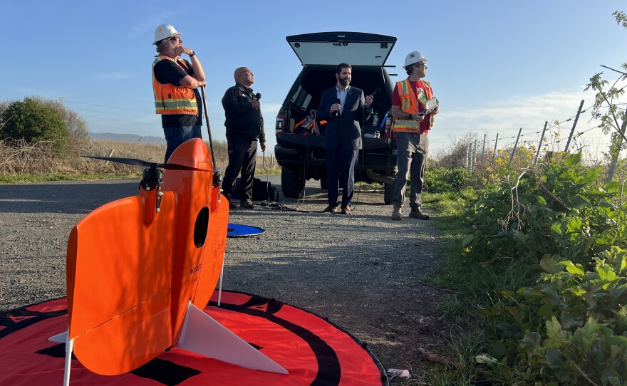
FREDERICKSON: And so we have, the larger drone. So the big orange drone on the larger launchpad is, fixed wing drone, and that we carry a multispectral camera.
FLAMER: How does a spectral camera work?
FREDERICKSON: I think it's voodoo science, but, so you have different cameras, and there's, like, six different lenses to it, and you're getting the reflectance off the plant pretty much like what it's absorbing and what's bouncing back of sunlight.
FLAMER: And what's the point of that?
FREDERICKSON: Plant health. And then also different plant species can have different reflectance is due to the different amount of chlorophyl, the fixed wing drones used for larger areas. The Willits mitigation parcel is about 1200 acres to 1500 acres. And then Tuluwat Iisland where we have a spartina removal. Hold on. You have a what removal.
FLAMER: Hold on, what?
FREDERICKSON: So spartina is like an invasive cordgrass, I believe, and is taking over Humboldt Bay. And part another mitigation component to Eureka Arcata corridor is removing the spartina on Tululwat Island. And so if you ever seen like, people out there weed whacking or the marsh master mowing that, they're removing that. So we flew that prior to that work.
And then we're going to do some monitoring after that with our drone and our multispectral camera, and try to monitor that change over time from invasive species to more natural species that, can occupy it.
CARVAJAL: Now, there's real science to this. You're a product of education, I get that, but that's not really what you went to study in school, as I understand that, you went for a different purpose, and I think folks would be interested to hear about that.
FREDERICKSON:
Well, originally I went to fishery science and Oregon State, a little bit of an early midlife crisis. I went back to Davis, for brewing science. And so I have a certificate in brewing science for their program. And then I went and brew beer for a few years at a microbrewery up in Oregon.
And so from UC Davis to Oregon. And then it was time to come back.
FREDERICKSON:
Yeah. Time to go back to natural resources. I miss, being in the field, being in the creeks. And I never know. I never knew fisheries that lead me to drones. <LAUGHTER>
FLAMER: As you were flying this and you're zooming in different places at the marsh or zooming in anywhere, have you seen things that you kind of wish you didn't see?
WRIGHT: No, no.
FREDERICKSON: We work for a state agency. So we're cognizant of all federal and state laws. And there's a California Privacy Act law. And so even though there’s airspace you're allowed to be over - private property - we try to be very cognizant of staying in our right away, especially when we first started. There's still a lot of grows in southern Humboldt.
WRIGHT: We always get permission before flying over, over property and even sometimes when we're flying the highway, we let CHP know, we don't fly like bridge level height. We're well above. We try or under it. Yeah, or under the bridge also. So.
FLAMER: So you fly under the bridge?
WRIGHT: After the big earthquake a few years ago, we got to fly under a bridge looking at cracks, and then taking photos from somewhere safe so they don't have to risk themselves getting down under the bridge. You know, all through the difficult to reach areas of bridges, fly through trestles.
FREDERICKSON: A biologist wants to look at these piers. And the only real way without drones would be we call a ‘snooper truck’. You have to do a lane closure. You have a truck that has an arm that goes underneath, and you have people in the bucket to go look at it. And that's time consuming, expensive.
And with this drone, we can put this up. Had a few people there and we can look at the bridge. We can look down on these piers and scope and see if there's any birds or bats.
…And so now it's going to land itself. The camera locks in on it should it lock, it should land right in the center.
CARVAJAL: And for the record, the bullseye is probably about one foot by one foot. And Keith is running for cover.
FLAMER: I'm running for cover because.
CARVAJAL: And I don't blame him.
FLAMER: Self- flying drone! I don't think so. And it's hovering…
CARVAJAL: Bullseye. He hit the target.
FREDERICKSON: That was all me, Jeff.

